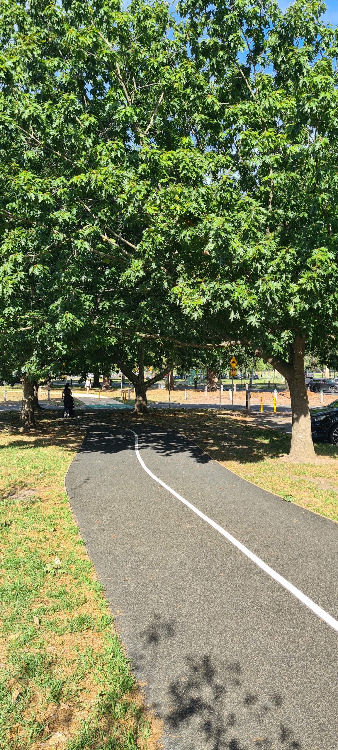
The shared users path link in Heidelberg Park is now complete!
We have delivered an action in the Heidelberg Park Masterplan - a shared user path link through the existing carpark. This new link creates a safer route through the carpark that connects the two existing trails.
The path is partly made of recycled tyres, a product developed in Melbourne, which allows water to pass through it and is more resistant to root damage than concrete. This will help protect existing and future trees while diverting waste from landfill.
Several advanced trees have been placed near the path to provide shade and offset the single tree being removed for the path construction. There will be no loss of existing carparks.
Shared user path link at Heidelberg Park
View photos of the completed shared user path.


Stage 1
Vision and priorities
We wanted to understand your experiences, usage and ideas to improve Heidelberg Park. This stage is now complete.
Stage 2
Draft Heidelberg Park Masterplan
Stage 2 consultation took place in April 2022. During this stage we wanted to test the draft Masterplan with you to make sure we were on the right track and see if we missed anything. This stage is now complete.
Participation in Stage 2 consultation included:
- 101 people left feedback on our online engagement platform Shaping Banyule
- 11 people spoke with Council officers at the pop-up session
- 8 written submissions were received from 8 individuals.
A consultation summary report can be found here.
Following the April 2022 consultation, the following changes were made to the draft Masterplan:
- Carpark shared path link. The number of car park bay losses has been reduced to install a shared path through the car park. This action is pending outcomes of a future usage study of the car park and shared path.
- Heidelberg Park Oval. The installation of the white picket fence been removed and replaced with a black mesh and metal fence.
- Beverley Road crossing. Safety of the existing pedestrian crossing has been improved.
- Beverley Road. Safety has been increased along Beverley Road for all users.
- Oval pavilion. Paths and landscaping around the pavilion have been improved, including more seats, bins, drinking fountains and bike racks.
- Storm water harvesting. Council will investigate installing underground rain water tanks.
- Path lighting. The revised Masterplan includes installation of new path lights, pending outcomes of a lighting study.
- Bike and pedestrian separation. Cyclists and pedestrians will be separated to increase safety, pending outcomes of a usage study.
- Path signage. It is proposed to install path signage to improve wayfinding.
- Tree management plan. A tree management plan is proposed to protect and enhance existing trees within the park.
- Interpretation and information signage. Install tree identification signage and first nation cultural heritage signage, in consultation with the Wurrundjeri Woi-wurrung Cultural Heritage Aboriginal Corporation.
- Background report. The revised Masterplan has also been amended to include newly endorsed Council and State government strategies and documents.
Stage 3
Public exhibition
Stage 3 consultation took place from July - August 2022. During this stage we asked for your thoughts on the draft Heidelberg Park Masterplan and if there was anything missing. This stage is now complete.
Participation in Stage 3 consultation included:
- 41 people left feedback on our online engagement platform Shaping Banyule
- 692 viewed the project page on Shaping Banyule
- 2 written submissions were received
Following the July/August 2022 consultation, there were four amendment made to the Masterplan.
- amendment to the indicative plant species selection process
- Species selection is based on micro climate, stock availability and climate change adaptability.
- Review of suitable species will be done on an ongoing basis based on the success of future planting.
- Tree species that are not considered vulnerable, or considered moderately
vulnerable are preferred (refer to pg. 23 -25)
- addition of several species in the indicative plant species lists (refer to pg. 23 - 25)
- reduction of the size of the Brown Street picnic area
- inclusion of masterplan action (No. 36) to upgrade existing Darebin Street path to a shared trail, as mentioned in the consultation and as outlined in the Heidelberg Activity Centre and Medical Precinct Public Realm Strategy 2019.
View the full consultation summary report.
Masterplan adoption
The Heidelberg Park Masterplan was adopted by Council on 6 February 2023 with four amendments:
- amendment to the indicative plant species selection process
- Species selection is based on micro climate, stock availability and climate change adaptability.
- Review of suitable species will be done on an ongoing basis based on the success of future planting.
- Tree species that are not considered vulnerable, or considered moderately
vulnerable are preferred (refer to pg. 23 -25)
- addition of several species in the indicative plant species lists (refer to pg. 23 - 25)
- reduction of the size of the Brown Street picnic area
- inclusion of masterplan action (No. 36) to upgrade existing Darebin Street path to a shared trail, as mentioned in the consultation and as outlined in the Heidelberg Activity Centre and Medical Precinct Public Realm Strategy 2019.
Watch a recording of the Council Meeting or view the Council minutes and report here.
Project participation
The endorsed Masterplan was developed after three phases of public consultation (details below). During this time, the following levels of participation were achieved:
The final Masterplan was supported by the local community with 87% of respondents confirming they support the inclusions to the document.
Your feedback throughout all three stages of consultation was used to help us finalise our Heidelberg Park Masterplan, which will inform our advocacy efforts to State and Federal Government agencies that own sections of the land, as well as our own infrastructure program.
Background
Heidelberg Park, with its mature trees, historic values and diverse topography, has a unique charm which attracts local residents, workers and visitors to the area.
It is approximately 14 hectares and is located within the Heidelberg Activity Centre. Park facilities include a network of paths, an oval, pavilion, carpark, toilets, rotunda and picnic facilities. Salt Creek also meanders through the centre of the park.
Heidelberg Park is one of many interconnected parks and reserves located along the Yarra River that provide both active and passive recreation opportunities. It is a Crown Allotment and Banyule City Council is the Committee of Management.
With the local population projected to grow, it is anticipated that the park will increase in popularity and we need to plan for this now.
The Heidelberg Park Masterplan will guide the future improvement, maintenance and management of the park. It will ensure that the park's heritage and cultural values are preserved and that we continue to provide a high quality, sustainable, accessible, safe, inclusive and well-maintained park that promotes health and wellbeing.
History of the site
Heidelberg Park is historically, aesthetically and socially significant.
Historical significance: Heidelberg Park was one of the first suburban parks in Melbourne, and is associated with Thomas Wills and the 1867 Aboriginal cricket team, as well as with Guilfoyle who visited the site in 1882 to provide advice on design.
Aesthetic significance: The landscape of the steep Salt Creek Valley, the large number of surviving tall conifers and the deciduous exotic trees from the 1880's are of aesthetic significance. The 1915 grafted elms which form the 'Wishing Tree' entry to the park off Burgundy Street east are an example of an unusual horticultural practice. The steep embankment or ridge line separating Salt Creek from the rest of the park provides an attractive setting of enclosure for the sporting ground to the east.
Social significance: Its continuous use as a recreational site since the 1850's, including horse racing, sporting teams, picnicking and other community activities, are of social significance to Banyule.
Our approach
To ensure the vision for the Heidelberg Park Masterplan reflected your needs, aspirations and expectations, we completed three stages of community consultation, offering pop-up information sessions and online workshops for you to have your say.
We also engaged internal and external stakeholders including the Wurrundjeri Woi-wurrung Cultural Heritage Aboriginal Corporation, Heidelberg Junior Football Club, Heidelberg West Football Club, West Heidelberg Cricket Club and Wild Stride Fitness.
The three stages of consultation included:
Stage One: Vision and Priorities. During this stage we sought to understand your experiences, usage and ideas to improve Heidelberg Park. This stage is complete.
Stage Two: Draft Heidelberg Park Masterplan. Using your feedback from Stage One, we developed a draft Masterplan for you to review, provide feedback and tell us if we missed anything. This stage is complete.
Stage Three: Public exhibition of the draft Heidelberg Park Masterplan. Using your feedback from Stage Two, we want to know if we got it right? This is the final stage of consultation before the Masterplan goes to Council for adoption.
We also completed a feature and level survey, arboriculture report, background report, site analysis and heritage and cultural investigation.


